I'm dragging today. I woke up around 5am after having nightmares about being chased by a Nurse Ratched type character. Hell if I know what it was all about. She got me in the end - cornering me in the bedroom and jabbing a long needle into my forearm.
After that I was pretty much awake. I decided to make up for a slothful and drunken weekend and go to the gym before work. I got there all hopped up on caffeine, and was tearing through my workout until about 7:30 - at which point all my energy disappeared into the ether. I was like the Energizer Bunny on Brand X batteries. I could feel the juice leaking out.
And while I wasn't looking, Hurricane Ioke popped up out of nowhere. I was looking at the surf reports, and saw this: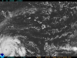
It was a surprise, needless to say. Hector is still far to the east and barely hanging on. There was nothing going on this weekend to suggest that another hurricane was forming just to the south of us. And yet the satellite photo is pretty clear.
It took everyone by surprise. No hurricane has formed in the Central Pacific since 2002. The tracking sites I use don't even have enough data to model historical tracks. Right now NOAA is confident that Ioke will hit Johnson Island and will miss us entirely. We'll see. Hurricanes are sneaky buggers.
What I'm most curious about is: what will happen to the south swell coming our way? Will a swell pass through a hurricane? Change direction? Or be wiped out entirely? I checked with Dolan [he of the Mesoscale Eddy lesson], and his guess is that it depends on the quadrant, and that the swell will most likely be subsumed by the storm.
Either way, we should have some interesting water by mid week.
After that I was pretty much awake. I decided to make up for a slothful and drunken weekend and go to the gym before work. I got there all hopped up on caffeine, and was tearing through my workout until about 7:30 - at which point all my energy disappeared into the ether. I was like the Energizer Bunny on Brand X batteries. I could feel the juice leaking out.
And while I wasn't looking, Hurricane Ioke popped up out of nowhere. I was looking at the surf reports, and saw this:

It was a surprise, needless to say. Hector is still far to the east and barely hanging on. There was nothing going on this weekend to suggest that another hurricane was forming just to the south of us. And yet the satellite photo is pretty clear.
It took everyone by surprise. No hurricane has formed in the Central Pacific since 2002. The tracking sites I use don't even have enough data to model historical tracks. Right now NOAA is confident that Ioke will hit Johnson Island and will miss us entirely. We'll see. Hurricanes are sneaky buggers.
What I'm most curious about is: what will happen to the south swell coming our way? Will a swell pass through a hurricane? Change direction? Or be wiped out entirely? I checked with Dolan [he of the Mesoscale Eddy lesson], and his guess is that it depends on the quadrant, and that the swell will most likely be subsumed by the storm.
Either way, we should have some interesting water by mid week.
No comments:
Post a Comment